
So, from #10 on my 2009 climb list (which is in absolutely no particular order) ... Whitehorse. The first real climbing expedition of the year, and one fraught with a bit of joy, misery, frustration and one close call (much, much too close).
Despite the spectacularness of this mountain, and its proximity to civilization (from six thousand feet above the valley floor we could still see the convenience store we had passed on the corner of the short road leading to the trailhead) – Whitehorse sees very little climbing activity and a party is quite assured of having a route completely to themselves. Well, there was a Prius parked at the barricade when we pulled up in Oliver but alas – as we found out afterwards – they had taken the other route (in other words, the easy one) so we did indeed have the Whitehorse Glacier completely to ourselves.
The line up the glacier is fantasticly wild, but to keep from jumping ahead ... getting there required an extra two-and-a-half miles of walking up what was described as being a road (the extra mileage because of that aforementioned barricade at a bridge that had washed out and never fixed). I am not sure when that happened, but given the condition of the "road" we walked up it must have been sometime before the advent of the four-stroke, combustion engine. I didn't mind the walk up the road, knowing no vehicle would be able to endure it. As it turned out, Matthew noticed on the way back a mineshaft at road's end – we surmised it was perhaps during the Darrington gold rush back in the late 1890s that the road was last in service.
But we covered the two-and-a-half miles easily, bringing us face-to-face with Snow Creek and a large log serving the purpose of a slippery bridge. No worries and we were easily across it, bringing us face-to-face now with the largest avalanche debris pile I have ever seen. Seriously. It was enormous. Hard to describe, but enormous chunks of icy snow the size of boulders (it was much like a huge talus field, only instead of actual boulders it was literred with billions and billions (to quote Sagan) chunks of ice and snow. Probably a quarter mile in length and at least a few hundred feet in elevation – not at all unlike (though I am admittedly not speaking from experience here) the Khumbu Icefall on Everest (OK, so not that big of scale, but impressive nonetheless – seriously).
So we navigated our way up and over and through the fans of avalanche debris (I had wondered how this amount of chunks of snow could amass but the Whitehorse Glacier rises nearly a vertical mile just about straight up from here, and apparently a lot falls down) and once reaching the top found ourselves face-to-face with a rocky headwall over which was cascading a small waterfall of melting ice and snow. The headwall was not large – maybe ten or twelve feet high at most – but formidable. With really no where to place any pro (not that we had brought any in any case, except for two pickets between the two us and my thirty meter glacier rope) we had to find another way. The rock was smooth, slippery, and a fall would have been very bad (in addition to the fact we did not know how we would get back down this because we could not be sure there would be a decent place above in which to attach a sling to use for a rappel).
The only option that left us it seemed – and unfortunately at that – was the infamous slide alder slopes (complete with devil's club) of Whitehorse. So we backed down about fifty feet to an inclined ramp leading to who knows where through dense alder. We hoped it was to snow that would then take us up onto the glacier. After about fifteen minutes of joy, pulling on slippery alder (and every so often one that wasn't actually attached to anything) and such, we emerged indeed onto a snow field that led up. And up. And up.
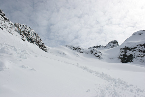
The cool factor of the Whitehorse Glacier route was the glacier itself and the fact that it is an unrelenting climb on forty-five-degree ice and snow for (like I said) nearly a vertical mile. So off we went. The snow was decent. Decent enough that at about twenty-four hundred feet (we had started at four hundred feet) we made the call to ditch our snowshoes, hoping (I should say gambling) that the snow would not worsen higher up. I am not entirely sure of our logic – perhaps that above would have stayed colder even through the warmer weather we were having and so it would be at least as firm up there (if not more so), despite above the north face the snow got a bit of sun? Soon after making this call, we could tell we were on the glacier for real because it was iced over nicely – forcing us to put on our crampons and have a go at what turned out to be thirteen hundred feet of front-pointing on crampons (a joy – seriously – and one I had not done too much of before this). You could look between your legs a long way down, all the way to the creek where we had crossed – which seemed to be nearly directly below us albeit about three thousand feet lower.
At the top of the icy section, we stopped for a bit of a break and to admire the view we had earned. We could see Baker, seemingly close enough to touch. And Shuksan, which seemed dwarfed by its volcanic neighbor. All other directions of view were still blocked by, well, the mountain we were climbing. And so off we went, only to immediately find ourselves no longer blissfully cramponing up frozen glacier slopes, but instead sinking up to our knees in powder snow. Matthew took off in one direction, me in another – the two of us separated by a small ridge leading up the glacier. After a couple hundred feet, I adopted a technique where I attempted to spread out my weight by quite literally crawling up the glacier. It was fortunate it was as steep as it was and so it facilitated this rather strange method quite nicely, and I would gingerly place each foot at a specific angle so that my shin and knee would hit the snow and sort of keep me from sinking much past my ankles. I was surprised at how well this worked, and though slow I seemed to make decent progress without getting overly exhausted.
I passed by some fantastic and enormous crevasses (all the more reason to be spreading out my weight, as Matthew and I clearly were unroped) without worry. The snow was powerdery but firm at the same time, and neither of us had felt any concern for avalanches (although we witnessed some on the opposite side of the glacier, but mostly from snow melting on the rocks high above). We were keeping an eye out for the occasional rock flying past or other debris but only saw one rock and those couple of slides in the distance. In any case, the glacier was impressive and I was having an enjoyable time despite the deteriorating snow conditions as we made it higher and higher. I stopped at one immense crevasse, eyeing it over in the direction of where I knew Matthew would be popping up knowing there was no way he would be able to get around it, then seeing his head pop up from behind the ridge – I yelled to him to move far to his right in order to get around it and meet up with my trail.
Waiting for him, I had a bit to eat then was off – breaking trail for the two of us and pushing myself back up the unrelenting slopes of the glacier while Matthew took a break himself. The technique ceased to be effective as the snow warmed up, and I found myself mostly breaking through to my knees on every step. It became exhausting. We switched leads. Matthew would take over breaking trail and I would quietly follow in his footsteps, then reverse. Our pace slowed to a crawl. At one point we took off our crampons, knowing their weight and the snow stuck to them was just making our effort that much more difficult. The sound they made though – crunching through the snow – reminded me of a scene in Touching the Void where they are descending the ridge in sheer exhaustion, their crampons making that very distinct sound with each step.
With Matthew in the lead, we reached the basin at the top of the glacier and found ourselves surrounded with high points in every direction. Matthew remembered reading that the USGS map (from which the Green Trails map that I had in my pack was based) had the summit mis-represented, and that it was not the point on the map but one of the others. We could not tell from our vantage point necessarily which one was higher and we were coming dangerously close to our turnaround time (unless we accepted a downclimb in the dark, for which neither one of us was particularly fond). I offered the suggestion to try climbing to the top of the ridge ahead of us (to the east) to take a peak over – thinking perhaps the summit was out of sight from where we stood.
And so I led off, breaking trail again as the wind picked up. We got close to the crest of the ridge (and I was somewhat concerned, thinking it might be a corniced edge and not wanting to punch through to some void on the other side) before getting turned back by a seemingly uncrossable moat that I kept nearly falling into (it was hidden – meaning a sort-of snow bridge between the snow and the rock which was completely under the snow was covering up the gap between the glacier and the rock). I tried traversing to the left to see if we could get around, but as I moved right the slope around and up to the ridge increased dramatically and so we stopped for a bit of a pow-wow.
At that point, not knowing what was actually the summit and the options either too far off to make it pointless on this go or just plain still out of sight, we gave up and quickly glissaded down out of the bowl to a point where Baker was back in view. There we sat down and for a rest and some more to eat, enjoying the peace of the mountains. Here we talked a bit about the proximity of Whitehorse and the whole being able to see the convenience store factor versus getting further out (we had mentioned the Pickets, which are the most remote section of the North Cascades). Both of us agreed that these day trips were enjoyable, but we missed really being away from it all in a sense. Then we began the long, long descent.
This involved some glissading higher up on the glacier where we could build up some speed. Coming to one point with me in the lead, I saw my tracks head left and around a bend and thought since we were going down rather than up we could get by just keeping in the direction we were going rather than the bit of a detour I had taken climbing up. And so I began another glissade, much like the other glissades I had been having some fun with so far. Except on this one the snow turned hard and icy. Fast. Before this point it was soft (almost too soft to even get any real speed, and stopping had up-to-this-point involved just sticking my feet into the snow). And then it got steeper. Fast. And I sped up, and could tell I was heading for the edge of a cliff (the same cliff I had bypassed on the way up, which is why I headed around it after trying my luck at getting up and realizing it was not going to happen – those tracks I thought I could bypass now on the way down). I flipped over out of instinct, frantically digging my ice ax into the ice to try to keep from experiencing free fall on a glacier. In a second I was at the edge and at the very last moment stopped.
This all happened in the span of a few seconds. I was rattled a bit but perhaps surprisingly calm despite the fact I came within literally a foot or two of flying over the edge of about a twenty foot drop. Stupid, I told myself. Fucking stupid. I am always cautious glissading, making sure never to get too out of control and stopping myself if I get going too fast. But this happened way too quickly. Instinct is everything in the mountains, and had I really listened to mine I would have followed my path around knowing if I had come up it I would be able to get down it. And of course then I had to climb back up to that point anyways, telling Matthew (who had been waiting at the top where I had begun the glissade watching me nearly go over the edge) that we could not get down that way because of the cliff that I, well, nearly flew over.
And so after that bit of excitement we continued down, sinking to our knees in snow that kept getting softer and wetter as we lost elevation. At one point, I made the remark that it felt like we were seriously swimming in snow. It was a strange sensation. At another point I sank up to my waist, and felt my right foot cemented in the heavy snow. I could not get it out. And so I had to awkwardly dig my right leg out – part with my hands, part with my ice ax, uttering a few choice words in the process. Good times. We still had a couple thousand feet of snow to descend.
We crossed paths with where we had cached our snowshoes, stopped and reattached them to our packs before continuing down to the point where we had broken through the mess of slide alder. Hoping not to have to downclimb that bit, we continued on our present course, looking for a better option. When the snow ended soon after that point, we made a go of a slope following a small creek and waterfall only to realize it too ended in an abrupt cliff. But much to our luck, we were able to skirt the cliff to the left and were presented with a fairly easy slope leading down to a snow slope which then led back to the enormous avalanche debris fans.
I stumbled my way back through the maze of the ginormous snow chunks before crashing at a point back at the creek near the log we had crossed nearly ten hours earlier, fairly wiped. Our feet had been swimming in our shoes for at least an hour, so we took this opportunity to take them off and wring out our socks like mops (along with the inserts), me joking to Matthew asking if he needed any drinking water. We sat there next to the creek for a bit letting our feet dry (of course realizing at the same point we still had about three miles left to walk and unless we were going to do it barefoot we were going to have to put back on our soaked socks and boots so it was fairly pointless, but felt good all the same).
After that we were off, crossing the creek in short order and noticing now the entrance to that mine we had missed on our approach. We took a quick look inside but couldn't see very far (in addition to it being mildly creepy, at least to me but perhaps only out of a sense of claustrophobia) before strolling back down the road, immersed in conversation about mountains, climbing, catching up, wormhole theory and the origin of the universe, and a book entitled Guns, Germs, and Steel that Matthew read dealing with – from a biological perspective – why Europeans led to ruling the world (so to speak). The author's thesis was interesting I thought (it had a lot to do with germs and immunity due to the nature of the early European society), and it tied into my having mentioned how my father grew up on a farm and rarely (if ever) gets sick (when he retired he cashed out I believe something like two years of sick time).
And after that enjoyable stroll, we found ourselves crossing the washed out bridge and finding Oliver waiting. I realized a while earlier in the day I had forgotten the requisite flipflops but oh well – changed into jeans and a t-shirt (cotton of course) layered with a wool sweater (it had clouded up and gotten a bit chilly) and after finishing heard a noise coming from the bridge. I looked up to see the two Prius guys heading our way. We chatted a bit – they had taken the standard route up the trail through a forested ridge and had apparently made the summit. Damn. Matthew and I didn't want to admit it out loud (though eventually we did) that frustrated us, although we took comfort knowing we would not have wanted to climb that route and were happy with our decision to give the glacier – complete with its hardships – a go.
We headed into town for a bite to eat, stopping on the way to eye the mountain from a bit wider perspective, trying to decide which point we had been seeing up in the basin that might have been the summit. We were not sure why it was so confusing up there trying to figure that out, but from a certain perspective it is tough to negotiate which point might be a couple hundred feet higher than another. I don't think we ever came to an affirmative conclusion, and left it at we will need to figure that out before heading up Whitehorse again (which we wholly intend to do, most likely next winter before the snow turns soft like it had for us this time around).
We ended up at a place called Skidders Bar and Grill (mainly cos we each wanted a beer, something the Burger Barn probably didn't offer). There was only one car in the parking lot (on a Saturday night), so we were somewhat hesitant - but they offered something called 'The Champ' burger which was begging us to try. Soon after ordering, we were the only ones in the place. Until Don showed up and started setting up for karaoke. Ooh, boy – Matthew remarked it was a sure sign of bad times when a place stoops to the level of using karaoke to bring in the crowds. We hurried up and ate, just in time to miss some country song about sparing a horse and riding a cowboy instead. Matthew admitted he liked the small town feel (he lives on Vashon), but found nothing at all appealing about the town of Darrington. I had to agree, and we took a quick stroll past the Red Top Tavern across the street, its parking lot jammed pack. He declined my offer to get another beer, so we jumped back in the car for the drive home.
All in all a good and challenging day out, and I try not to think too much of what might have been had I careened over the edge of that cliff five thousand feet above the valley because, well, it didn't happen. Of course we had a good time, as we always do – and I am similarly of course looking forward to our next outing (and we made some concrete though still tentative plans on a bid for a Stuart range traverse later in the summer which would be fantastic – #4 on the list).
No comments:
Post a Comment